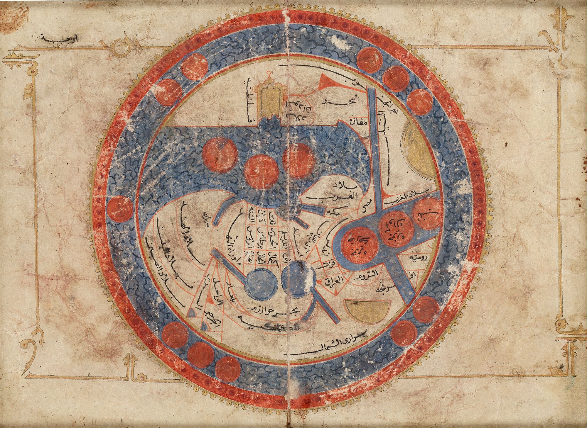
A PERSIAN MINIATURE MAP
After ISAL-ISTAKHRI. The world, centering on the Persian Gulf. Ottoman province, c. 1820. 260 x 290mm. World map in manuscript. Drawn on paper with watercolour, ink, gouache and gold highlighting. World map in manuscript with inscriptions in Arabic showing a map of the world centered on the Jezirah. This map is based on al-Istakhri's world map (977/1570 A.D). Oriented with South at the top, just as in the T-O maps of contemporary Latin Europe, but instead of the Earthly Paradise the Arab scholars knew enough to place in the furthest East both China and Tibet. The map shows Egypt and the river Nile in the right and further on "Country of the Black People". Note how the tip of Africa points eastwards, a mistake which the Chinese geographers were the first to correct. In the lower right corner Europe, i.e. "Country of the Romans and Franks".. " The map shows the Indus in the lower left, with the Indian Peninsula, Tibet and Chinese Empire and The Red Sea coloured in red. The outer circles represent the seas. The manuscript is a cosmology, not meant to be accurate geographically, but only to present the reader with a systematic overview of the existing knowledge about the world at the time. According to Arab geographical theory based entirely on Ptolemy, this would be a sphere. Since the far side of a world sphere (an upside-down world) was practically inconceivable, only a hemisphere was thought to be inhabitable. This could easily be “projected” onto a flat area and represented by a circle. That Ptolemy represented the inhabitable world as occupying 180 degrees of the earth supported this idea. Thus al- Istakhri represented the world as a circle surrounded by the Encompassing Sea, with the two main seas reaching in from the east and the west toward the center, where they would join except for a small, narrow land barrier—the barzakh of the Qur’an . In his text, al-Istakhri gives a simple description of the world to explain his map. “The earth is divided into two by the two seas, so that we have a north or cold half and a south or hot half. People in these two halves get blacker as you go south and whiter as you go north etc.” The main kingdoms are listed together with the kingdoms that adjoin them. This is the only place where non-Islamic areas are given any mention. Measurements are attempted; thus the width from the Encircling Ocean in northwestern Africa to the ocean in China was 400 days’ journey. However, the distance north to south was not measurable. There were 210 days’ journey through inhabitable lands, but the extreme north was uninhabited because of intense cold and the extreme south because of intense heat. The seas were described briefly, and the fact that the Khazar [Caspian] Sea and the Khwarazm [Aral] Sea were landlocked is mentioned, as well as the sea connection between the Encircling Ocean and Istanbul—that is, the Baltic joins up to the Bosporus.
19 by 26 cm.